Broomfield Tavern, 15-16 Broomfield Place, Spon End
 The first mention of Spon is in the list of places the parochial rights of which were granted, or re-granted, by Ranulf de Gernon, Earl of Chester, to the priory of Coventry in the early 12th century. In this list there were 8 vills (villages) that were to become parishes; the vills of Bisseley, Keresley, Pinley, Spon and Whitley that were to remain in St Michael's parish and the vill of Whoberley which lay partly within Stoneleigh parish. Spon continues to be referred to as a vill in the 13th century, when it had its own common, fields, wood, mill and waste. Spon bridge was in existence by the late 13th century.
Spon's common fields later became Coventry's Lammas and Michaelmas lands at Spon End and around. The common meadows were called the Lammas lands and were enclosed from Candlemas Day (2nd February) until Lammas Day (1st August) when they were thrown open until the next Candlemas Day. The Michaelmas lands were common arable fields which could be enclosed for cultivation in strips every year from Candlemas Day (2nd February) to Michaelmas Day (29th September), when they had to be thrown open for common use until the next Candlemas Day. The Coventry freeman's entitlement (or 'stint') to the meadows was to graze two horses and one cow or two cows and one horse.
These Lammas and Michaelmas lands occupied most of the land round the western perimeter of the city. Then there were commons at Radford and Whitley along with Barras Green, Stoke Green and Stoke Heath. On top of this, Cheylesmore Park lay to the south whilst to the south east was an entailed estate which could not be developed for building. The effect of all this was a stranglehold on the expansion of the city.
Yet, by the early 19th century, the steadily increasing industrial population of Coventry created a mounting pressure for building land. As a partial solution, all available land in the city itself was brought in to use for erecting worker's houses, creating courts in the gardens of houses on the thoroughfares. Then from 1828, the so-called 'New Town' of Hillfields was built
Meanwhile, to the west of the city, between Spon Street and Hertford Street, development had taken place in the 1820s along the north side of Summerland Butts Lane (The Butts and Queens Road). After 1832 the land further north was built up with streets of small houses and Crow Moat was filled in. Poddy Croft, a patch of Lammas land to the east of Crow Moat, remained as a garden until late in the 19th century. Beyond Spon End, a nursery garden at Chapel Fields, part of Sir Thomas White's charity lands, was laid out with streets of watchmakers houses from 1846 onwards.
However, the Lammas and Michaelmas lands remained. In 1849, William Ranger, Superintending Inspector of the Board of Health, visited Coventry to make observations and promote the setting up of a Board of Health in the city. His report stated that the city had suffered a cholera epidemic in 1832 and that the biggest killers were epidemics of scarlet fever and typhus. In the years 1840-1842 the death rate in Coventry was 4% above the national average. Ranger considered the main problem to be overcrowding due to the city's inability to expand over Lammas and Michaelmas lands. Ranger's report recommended the opening up of theses lands for building.
 The first encroachment on the Common lands was the building of the Coventry to Nuneaton branch railway from 1848 to 1849. The stone viaduct known as 'Spon Arches' was erected between August 1848 and June 1849. On 25 January 1857, eleven arches were taken down and replaced in blue brick but, up to arch No 7 and after arch No 17, the original sandstone structure still forms the viaduct.
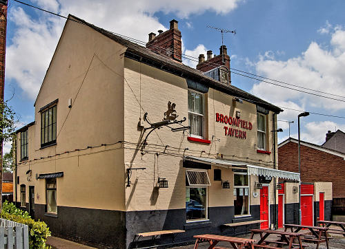
Right: The Broomfield Tavern in 2010. (Photo courtesy of Cliff Jones.)
So in July 1849 an attempt was made to effect an enclosure under the Enclosure Act, but the necessary one-third of interested parties would not assent so it failed. Another attempt was made in 1857, when the necessary proportion of assents was obtained and in 1860, 976 acres of Lammas and Michaelmas lands was allotted freehold to private individuals, various trusts and the corporation. In 1875 another award was made under the same act and the rest of the Lammas and Michaelmas lands were enclosed and so these ancient commons passed into history.
Shortly after the enclosure of 1860, Broomfield Terrace was laid out. Broomfield Terrace is not in the 1861 Census but on 10th May that year there is a transfer of the license from John Royle to Jack Crockford. In the 1871 Census, the occupant is John Francis, who is a 38 year old Watchmaker Finisher who was born in London. He has a wife, Eliza, 37 years old, and four sons and three daughters. As a watchmaker finisher, John Francis would have taken the component parts of a watch, supplied by other tradesmen in the area, and assembled the finished article, then checked its timekeeping, made any necessary adjustments and sold it on to the retail trade. As such, he would have been an important part of the watch trade and providing alcoholic refreshment to both his customers and suppliers must have made good sense. I have never seen any evidence that this was other than a full public house license.
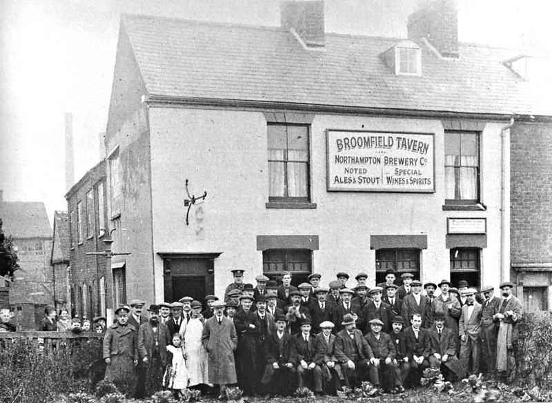
Amongst subsequent licensees, Harry Cramp is worthy of note as he was also Coventry's Town Crier. In 1979 the local real ale guide talked of excellent Ansell's Mild in a working class local. In fact, for many years this was a mild-only pub: the only ale it sold was mild through its handpumps. Although it was owned by Mann's, the mild it sold was Ansell's because of the excellent reputation of Ansell's Mild locally. The Ansell's beer was removed in 1982. Before Mann's, the pub is believed to have been owned by NBC (Northampton Brewing Company). In 1983 Chris Arnott called it, 'a typical village pub, although situated less than a mile from Coventry city centre. In the public bar most of the men sup mild ale and play dominoes, undisturbed by juke-box, space invaders or taped music'. The first encroachment on the Common lands was the building of the Coventry to Nuneaton branch railway from 1848 to 1849. The stone viaduct known as 'Spon Arches' was erected between August 1848 and June 1849. On 25 January 1857, eleven arches were taken down and replaced in blue brick but, up to arch No 7 and after arch No 17, the original sandstone structure still forms the viaduct.
Right: The Broomfield Tavern in 2010. (Photo courtesy of Cliff Jones.)
So in July 1849 an attempt was made to effect an enclosure under the Enclosure Act, but the necessary one-third of interested parties would not assent so it failed. Another attempt was made in 1857, when the necessary proportion of assents was obtained and in 1860, 976 acres of Lammas and Michaelmas lands was allotted freehold to private individuals, various trusts and the corporation. In 1875 another award was made under the same act and the rest of the Lammas and Michaelmas lands were enclosed and so these ancient commons passed into history.
Shortly after the enclosure of 1860, Broomfield Terrace was laid out. Broomfield Terrace is not in the 1861 Census but on 10th May that year there is a transfer of the license from John Royle to Jack Crockford. In the 1871 Census, the occupant is John Francis, who is a 38 year old Watchmaker Finisher who was born in London. He has a wife, Eliza, 37 years old, and four sons and three daughters. As a watchmaker finisher, John Francis would have taken the component parts of a watch, supplied by other tradesmen in the area, and assembled the finished article, then checked its timekeeping, made any necessary adjustments and sold it on to the retail trade. As such, he would have been an important part of the watch trade and providing alcoholic refreshment to both his customers and suppliers must have made good sense. I have never seen any evidence that this was other than a full public house license.
Amongst subsequent licensees, Harry Cramp is worthy of note as he was also Coventry's Town Crier. In 1979 the local real ale guide talked of excellent Ansell's Mild in a working class local. In fact, for many years this was a mild-only pub: the only ale it sold was mild through its handpumps. Although it was owned by Mann's, the mild it sold was Ansell's because of the excellent reputation of Ansell's Mild locally. The Ansell's beer was removed in 1982. Before Mann's, the pub is believed to have been owned by NBC (Northampton Brewing Company). In 1983 Chris Arnott called it, 'a typical village pub, although situated less than a mile from Coventry city centre. In the public bar most of the men sup mild ale and play dominoes, undisturbed by juke-box, space invaders or taped music'.
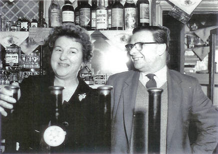
 Bill and May Toseland always smiling behind the bar at the Broomfield Tavern. (Photo from Jo Shepherd, daughter of Bill & May.) | |||
LICENSEES:1859 Joseph Bindley 1859 - 1861 John Royle 1861 Jack Crockford 1868 - 1871 John Francis, watchmaker finisher 1871 - 1881 Reuben H. Richardson 1884 Eliza Richardson 1884 - 1899 John Harrow 1899 - 1908 Mary Harrow 1908 - 1915 William Lunham Chapman 1915 - 1953 William Henry Cramp c1959 - 1963 Bill and May Toseland (see also Fox and Vivian and Navigation Inn) 1985 - 1986 David & Pauline Stidworthy 2011 Angie Cherry | |||
OWNERS:2011 Enterprise Inns 2014 Angie Cherry | |||
| Previous page: Brooklands Hotel | This page: Broomfield Tavern | Next page: Browns |